Hurricane Ida New Orleans Flood, Wind, Rain History Maps
Storm surge flooding map & Leveed Areas in white above around the city.
Dixie Fire & Evacuation Map in Northern California
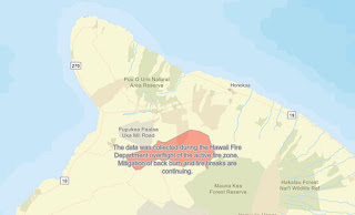
Hawaii Brushfire & Smoke Maps
4 days of the mountain burning seen with #GOES17. Heart wrenching just to watch - but far less so than for Hawaiian homestead residents on the front lines of this beast pic.twitter.com/1HCWsbrbh1
— Clay Trauernicht (@claytrau) August 3, 2021
Last time Hawaii had a fire burn >40,000 acres was 1969, the largest fire on record at >47,000. This one may be larger pic.twitter.com/OImPSq0MXH
— Clay Trauernicht (@claytrau) August 3, 2021
Palisades Topanga State Park Fire Map May 2021
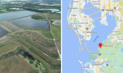
Where is Piney Point & Why Does It Have Toxic Waste Water?
A leak at an old phosphate plant site has threatened Tampa Bay for the last week with environmental catastrophe. Here we break down the pieces involved.
It used to be a fertilizer manufacturing facility. Industrial byproducts of that process are still stored on site. That includes polluted water and phosphogypsum, a substance kept in stacks and monitored for its radioactivity. Managing those materials is expensive and hasn’t always gone well at Piney Point. Past discharges have hit the valuable waters of Bishop Harbor. Excess nutrients from wastewater can feed harmful algal blooms, which lead to fish kills.
What’s a phosphogypsum stack?
Tips To Protect Yourself And Your Home From A Wildfire
With 2020 bringing some of the worst wildfires
on record, ravaged land, homes, and lives all the way from Australia to California,
its more important than ever to be prepared if you live in a hot area where
these things occur. But just what can you do if you are faced with an
uncontrollable wildfire on your doorstep?
Human Lives Come First
The lives of yourself, your family, and your
friends (and
animals)must come first in the event of a wildfire. While losing
your home and all your possessions is devastating, these things can eventually
be replaced. If you see a fire, make sure it has been reported and ensure you
listen to the instruction of emergency officials. They know what they are doing
and won’t advise you to evacuate if you don’t need to. Follow what they say and
don’t try to be a hero. You could just end up getting in the way and cause more
harm than good.
Protect Your Home
If you have time when evacuating, there are
a few things that you can do to protect your home. Turn off all gas and propane
at the meter and make sure all pilot lights are switched off. Next, turn on all
the interior and exterior lights in your house. This will make your home easier
to spot in the heavy smoke caused by wildfires. Remove wooden furniture and
combustible trash, and doormats away from the doors and windows.
You can also remove any kindling, firewood,
pine needles, or dead leaves around the house if you have the time. Finally,
wet down your house using lawn sprinkles and hoses. The roof and any vegetation
within 15 feet of your home should be wet down but don’t leave these running as
you can affect the area’s water pressure.
Before you leave, also make it easy for
firefighters to get in. Leave doors and gates unlatched. Connect your garden
hoses to your outside taps and leave buckets of water lying around for
firefighters to use. You can also put any ladders you have outside in case
firefighters need to use them to get onto your roof.
Don’t Start A Wildfire
While this may seem obvious, if you live in
an area prone to wildfires, make sure you don’t inadvertently cause one
yourself. Humans are the main cause of wildfires and while arson is
occasionally the cause of devastating fires, accidents are just as common.
Cigarettes that are poorly disposed of by
simply being tossed on the ground or out of a car window, can quickly cause
fires. These partially lit buds can cause serious damage. Cigarettes should
always be properly extinguished before disposable before being thrown away in a
sealed container. Unattended campfires can also have disastrous consequences,
so don’t leave them alone to play online.
Campfires or even fire pits near or in among
the trees always need to be unattended to and extinguished properly
at the end of an evening. Fireworks and flares also should never be handled by
amateurs as they can lead to injury and of course, fires.
The World’s Worst Earthquakes Of 2020
The Worst Earthquakes of 2020
Natural disasters seem to be part and
parcel of 2020, making it the worst year on record for many. Earthquakes
stretched the far reaches of the world this year, all the way from China to bucket
list destinations like the Caribbean, and Iran, Russia, Philippines,
India, and Turkey. In 2020, 45 earthquakes with over 6 magnitudes were
recorded. Here are some of the worst:
January Earthquake in Turkey
A magnitude 6.7 earthquake that hit Turkey
on the 24th of January is responsible for claiming the lives of 41 people
and injuring over 1,600 others. The country’s eastern provinces of Elazig and
Malatya provinces were the hardest hit with thousands of residents displaced
from their homes, although the earthquake was also felt in the neighboring
countries of Armenia, Syria, and Iran. Unfortunately, this wasn’t the only
earthquake to hit the region in 2020, with it lying on the active North
Anatolian Fault, between the Anatolian and Eurasian tectonic plates.
Earthquake and Tsunami Together
On the 30th of October 2020,
Turkey was again struck by another earthquake, this time in the Izmir province.
The magnitude 7 earthquake also hit the Greek island
of Samos, resulting in a tsunami that brought with it further destruction. In
total 119 lives were lost in the natural disaster, some 1,034 were injured,
many buildings were damaged or collapsed, and rescue efforts were extensive.
The earthquake was the deadliest of the
year and the most powerful recorded in the Aegean Sea since 1981. Prior to
this, the deadliest earthquake in Turkey’s Izmir province occurred in 1955 with
a 6.6 magnitude quake that claimed the lives of four people.
Earthquake at Russia's Kuril Islands
A 7.5 magnitude earthquake struck Russia’s
Kuril Islands on the 25th of March 2020. A volcanic archipelago, the
Kuril Islands stretch approximately 1,300 km northeast of Hokkaido and
contain some 56 islands. While the earthquake generated Tsunami warnings and a
possible threat to Japan, but thankfully no casualties were reported.
Alaska Peninsula Earthquake
On the 21st of July, a magnitude
7.8 earthquake struck undersea, some 65 miles off the coast of Alaska. Although
this was the strongest earthquake recorded in 2020 by magnitude, it caused severe damages. It did however prompt the evacuation of several coastal areas
as a preventative measure in the case of a tsunami. The fact that there wasn’t
one was as lucky as the players that check this site.
Mexico’s Oaxaca earthquake
A magnitude 7.4 earthquake struck the Mexican
state of Oaxaca on the 23rd of June 2020. The quake, whose epicenter
was recorded near San Miguel del Puerto, was felt by close to 50 million people
in both Mexico and Guatemala. Thousands of homes were damaged as a result of
the earthquake, and 10 deaths were recorded.
Iran Earthquake
On the 23rd of February, an
earthquake near Khoy in north-west Iran was recorded at a magnitude of 5.8. The
earthquake, whose epicenter was Qotur district, took the lives of 9 people in
Başkale in the Van province of neighboring Turkey. Just as the area as
recovering, a magnitude 6 earthquake hit the same place about 10 hours after
the first.
The Most Devastating Fires Of 2020
Strange Weather And Natural Disasters Of 2020
The Weirdest Natural Disasters of 2020
2020 was one of the most devastating on
record, not just because of the pandemic but also because of the wide range of natural
disasters that shook the world. These included devastating bush
fires in Australia and California, one of the worst Atlantic hurricane seasons
in history, and several volcanoes, flash floods, and earthquakes. There was also
a fair share of weird and wonderful occurrences. Let’s look at some of the
weirdest natural disasters of 2020:
The Snow Goes Green In Antarctica
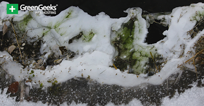
Parts of snow-covered Antarctica turned green this year in a response to climate change. Warmer temperatures and melting
snow resulted in blooms of algae which resulted in massive green patches
forming across the winter wonderland. These algal blooms expanded at such a
high rate and became so prolific that they were even visible from space.
Locusts Swam Africa and Asia
Locust swarms are not just something that
happened in Biblical days. 2020 saw millions of desert locusts swam over India
and East Africa. Making their way from East Africa, through Pakistan and onto
the Indian states of Rajasthan, Gujarat, Punjab, Haryana, Uttar Pradesh and
Madhya Pradesh, the locusts caused severe damage to crops. Although not a
direct threat to humans, locusts are some of the most destructive creatures in
the world, capable of devouring large sections of crops and grasses.
The swarms were one of the worst pest attacks
in over two decades and caused destruction in Djibouti, Ethiopia, Eritrea,
Kenya, Somalia, Sudan, Uganda, South Sudan, and Yemen. Somalia called a state of
national emergency in the wake of the infestation with food security under
serious threat. Again, this natural disaster has been attributed to climate
change and an increase in temperatures and unusually heavy rains which have
made the locusts breed and swarm in numbers. If you’re looking for better news,
register here.
A Bomb Cyclone In Canada
While Atlantic Canada is known for some
hectic storms, Newfoundland was hit by a record-setting bomb cyclone on the 17th
of January 2020. The cyclone brought with it the highest daily snowfall on
record, covering St John’s in 30 inches of snow.
Bomb cyclones are storms that intensify
very quickly, generally causing massive wind spirals at their base. This was
the case in Canada where winds of 97 mph caused snowdrifts to form, some
reaching 15 feet high. Vehicles,
roads, and homes were buried in snow and a small avalanche even caused
devastation in one resident’s home.
Midwest US Experiences Sahara Sandstorm
Africa’s Sahara Desert is no stranger to sandstorms and every sorry often plumes of air, laden with sand travel across the ocean during hurricane season. These sandstorms have even been known to reach the Caribbean and the Gulf Coast in the summer months. However, in June of 2020 a particularly dense dust plume made its way over to Puerto Rico, and even reached as far as parts of Midwest, United States, causing hazy skies over parts of Nebraska. This was one of the most magnificent Sahara dust events recorded in decades.
The World’s Worst Storms Of 2020
The Most Dangerous Storms of 2020
2020 was a horrific year for many with
death and disease some of the most talked-about subjects this year. However, for
many, the weather also presented itself in the extreme in 2020, causing
absolute havoc to land, livestock, livelihoods, and
lives, with severe storms that all but destroyed. Let’s look back at some of
the worst storms to hit the world in 2020.
The Atlantic Hurricane Season
The Atlantic Hurricane Season was no doubt
one of the worst on record. 2020 marked the only second time in history that
the entire alphabetical list of hurricane names was used up. This meant that
the Greek alphabet needed to be used to name future storms from as early as the
18th of September. 2020 heralded 30 named storms, which are storms
that reached 39 to 73 miles per hour, 13 hurricanes, and six major hurricanes.
September was the worst month with 10 named
storms recorded in this month alone. In fact, three storms, namely Wilfred,
Alpha and Beta, all formed on the same day on the 18th of September.
2020 also brought on a category 5 Hurricane in November with Hurricane Iota.
Hurricane’s Eta and Iota
It wasn’t just the United States that
experienced the devastation of 2020’s hurricanes. Hurricane Eta made landfall
in November in Nicaragua bringing with it large amounts of rainfall for an
extended period. This caused massive flooding in large parts of Guatemala,
Honduras, Mexico, and Panama resulting in the loss of 215 people with another
49 missing.
Just two weeks after the devastating
effects of Hurricane Eta, Hurricane Iota arrived. The storm made landfall just
15 miles from Eta’s location in a completely unprecedented event, again
bringing with it torrential rains. Combined tolls from the two hurricanes left
more than 300 dead or missing and an impact of around $738 million on the
country. In Honduras, damages from the hurricanes exceeded $10 billion, which
is a sizeable sum even by the standard of mega casino bonuses. $10
billion is around 40% of the country’s
GDP. This set the poverty-stricken nation back about 22 years in economic development.
Typhoon Vamco
Across the world in the Philippines, Typhoon Vamco caused devastation in Manila on the 13th of November. The typhoon was the 21st to hit the country in 2020 and no doubt the deadliest, killing over 40 people. It also resulted in some of the worst flooding the country has ever seen. Unfortunately, Vamco was subsequently followed by Typhoon Goni, the strongest Typhoon of the year which only compounded the damage already caused.
Popular Maps
-
How To Subscribe Visit the DisasterReliefMaps.com website. Sign in using your Google account to instantly access our extensive disaster...
-
In regions prone to severe weather conditions like tornadoes, having a storm shelter can provide essential protection for you and your fami...
-
Hurricane Ida Flood Map Storm surge flooding map & Leveed Areas in white above around the city. Wind history map Rain fall totals
-
The Most Dangerous Storms of 2020 2020 was a horrific year for many with death and disease some of the most talked-about subjects this yea...
-
In the adrenaline-fueled realm of storm chasing, a select group of individuals stand out as pioneers and experts in capturing nature's m...
-
According to Sheriff Eric Magrini, three people have died due to the Zogg Fire in Shasta County. Magrini gave no further information about...
-
In regions prone to tornadoes, the distinction between a tornado watch and a tornado warning can be crucial for residents and communities to...
-
Syndicated Maps Network of Map Apps How you add our web app to your iPhone home screen:


